Next on the agenda... make some miles north towards the Chesapeake. So, leaving Beaufort Sunday morning, Patti reflected that there was nothing she'd rather do for Mothers Day. At the Neuse River, we were able to sail FAST for a couple of hours, then turned up the Bay River to settle in for the night in Bonner Bay. Monday we were into Goose Creek and came out motorsailing in the Pamlico River, then up the Pungo when the winds got up over 20 knots - in the ICW?!? Motoring into the Alligator-Pungo Canal, the wind was blocked and we had a few hours of shear boredom ahead of us. Guess that's better than shear terror. Coming out the other end of the 20-mile ditch, we anchored in the Alligator.
Tuesday morning was beautiful, we saw two bald eagles perched in the same tree, and had a great time motorsailing up the Alligator. We decided to try the alternate route north through the Dismal Swamp Canal. As we entered the Albemarle Sound, the skies all around us were shades of gray and we saw storms everywhere. It was difficult to tell which way the storms were going. We listened to VHF weather radio and conditions were still forecast to be ok, so we ventured out for the 10-mile crossing to the Pasquotank River. Halfway across, a storm closed around us, and visibility diminished to 100 feet. We took our sail down and throttled back till we could figure out how long this storm would be with us. The good news is, we were getting a nice freshwater washdown for the deck with the hard rain. And, the wind and water didn't feel too strong since we were going downwind.
The storm cell moved on and we were clear to enter the Pasquotank. Turning on the weather radio again we NOW heard there were storm warnings for Albemarle Sound. The National Weather Service was warning mariners to get to port as soon as possible, and if in port, to stay there! They said that the winds in the storms were 33 knots (just under gale strength) and waves were up. Well, we certainly didn't feel all that, but the water was definitely breaking with white caps (though we would call them brown caps - the water here is brown from the wood tannins.) Now there was little wind, but we put the sail back up for some stability in the waves and motored into Elizabeth City, jumping off spot for the Dismal Swamp Canal. Anchor down in Forbes Bay, a beautiful place with pretty houses lining the shore.
Bonner Bay: +35° 9' 48.96", -76° 35' 41.70"
Alligator River: +35° 40' 23.70", -76° 5' 58.44"
Forbes Bay, Elizabeth City: +36° 17' 25.56", -76° 12' 3.06"


May 8-12, 2012... Back in Beaufort, NC
It is wonderful coming back to places we'd been before. Our last visit to Beaufort was in October 2009. So what's the same and what's different?
Same - we anchored off Radio Island.
Different - hardly any pelicans whereas hundreds were feeding here last time.
Same - surprisingly good restaurant, Aqua, for a small town - worth the stop.
Different - restaurant wasn't crowded - a seasonal thing?
Same - walk out to Piggly Wiggly supermarket to stock up.
Different - no smoking inside the store!
Another big difference this time around was spending time with MV and Shane on Gem, Australian friends we met in the Caribbean. They came to town from Cape Lookout and anchored near us by the beach at Radio Island. Great catching up and hearing about their travels since we last got together in Puerto Rico a year ago, and about their upcoming adventures in New York. They have kayaks too, so we all paddled over to Carrot Island to see the wild horses. Maybe we'll get to NY later this summer and will hang out with them again (MV and Shane, not the horses.)
We were in town during the Beaufort Music Festival so we listened to as many of the bands as we could. Quite a variety of styles. We were really impressed by the skills and enthusiasm of Old Man Markley, a punk bluegrass band. And we got a great aerobic workout dancing to the Phantom Playboys, a rockabilly band. By the second night, we were exhausted, and really sunburnt! So back to Anhinga; we prepared to leave town for points north.
Same - we anchored off Radio Island.
Different - hardly any pelicans whereas hundreds were feeding here last time.
Same - surprisingly good restaurant, Aqua, for a small town - worth the stop.
Different - restaurant wasn't crowded - a seasonal thing?
Same - walk out to Piggly Wiggly supermarket to stock up.
Different - no smoking inside the store!
Another big difference this time around was spending time with MV and Shane on Gem, Australian friends we met in the Caribbean. They came to town from Cape Lookout and anchored near us by the beach at Radio Island. Great catching up and hearing about their travels since we last got together in Puerto Rico a year ago, and about their upcoming adventures in New York. They have kayaks too, so we all paddled over to Carrot Island to see the wild horses. Maybe we'll get to NY later this summer and will hang out with them again (MV and Shane, not the horses.)
We were in town during the Beaufort Music Festival so we listened to as many of the bands as we could. Quite a variety of styles. We were really impressed by the skills and enthusiasm of Old Man Markley, a punk bluegrass band. And we got a great aerobic workout dancing to the Phantom Playboys, a rockabilly band. By the second night, we were exhausted, and really sunburnt! So back to Anhinga; we prepared to leave town for points north.
May 6-8, 2012... North Carolina Bound
Ever so sorry to leave our splendid isolation of Prince Creek, a look at the calendar told us we had to move on. Our goal was to make a short ocean hop up to Beaufort, NC. The choice was to double back to Winyah Bay to depart, or drive up to Masonboro Inlet at Wrightsville Beach and avoid Frying Pan Shoal off Cape Fear. The weather was looking good for a passage two days hence, so that decided it, we would move north to Masonboro.
Back into the ICW. For the first time since starting out in February, we were sharing the ditch with lots of sailboats making their way north. As anchoring spots were rare, we were a bit nervous about finding a place for the night. But, we soon learned that many ditch drivers simply go from marina to marina, leaving us to anchor alone both nights. We were traveling during the 'supermoon' so tides were higher and lower than usual. The impact on the marshes was impressive. At the Shallotte River, we anchored near grasses that within two hours had completely disappeared and we seemed to be in a wide open basin. It is disorienting when your reference points are gone. At Wrightsville Beach we anchored just inside the inlet and had a beautiful dune beach to ourselves.
The outside run to Beaufort was easy. We sailed for a couple of hours and then the wind completely died. Again. Seems to be a common refrain for our Atlantic passages. So, motorsailing the rest of the way, the water smoothed out and we were into Beaufort and anchored a few hours before sunset.
Shallotte River: +33° 54' 51.30", -78° 22' 14.76"
Wrightsville Beach: +34° 11' 36.54", -77° 48' 41.40"
Beaufort: +34° 42' 48.00", -76° 40' 46.56"
Back into the ICW. For the first time since starting out in February, we were sharing the ditch with lots of sailboats making their way north. As anchoring spots were rare, we were a bit nervous about finding a place for the night. But, we soon learned that many ditch drivers simply go from marina to marina, leaving us to anchor alone both nights. We were traveling during the 'supermoon' so tides were higher and lower than usual. The impact on the marshes was impressive. At the Shallotte River, we anchored near grasses that within two hours had completely disappeared and we seemed to be in a wide open basin. It is disorienting when your reference points are gone. At Wrightsville Beach we anchored just inside the inlet and had a beautiful dune beach to ourselves.
The outside run to Beaufort was easy. We sailed for a couple of hours and then the wind completely died. Again. Seems to be a common refrain for our Atlantic passages. So, motorsailing the rest of the way, the water smoothed out and we were into Beaufort and anchored a few hours before sunset.
Shallotte River: +33° 54' 51.30", -78° 22' 14.76"
Wrightsville Beach: +34° 11' 36.54", -77° 48' 41.40"
Beaufort: +34° 42' 48.00", -76° 40' 46.56"
May 3-5, 2012... Prince Creek, SC
Day 1 on Prince Creek: Beautiful sunrise, mirror-still water reflecting the trees, birds everywhere, kayak in the water. Today's objective - circumnavigate Longwood Island. Out paddling, John reveling in flowers he could photograph from the water. Mysterious creek - we enter - magnificent cypress swamp, herons dashing about, woodpeckers hammering away, what's that crazy sound? Try using the video feature on the camera to capture the sound. (didn't work...)


Creek ends; paddle back out to Prince to continue north. Turtle sunning on a log, then - what's that swimming up there? Turtle? No! ALLIGATOR! Patti freezes, John saying, let's get a little closer. OK. It sees us, then swims away. Patti trying to figure out how big that gator is from the part exposed above water... How big does it have to be before it can upend a kayak and devour the paddlers? Maybe we should have worn life jackets... Not 10 minutes later (after John has been consoling Patti saying that the alligator is more afraid of us than we are of him) another one surfaces sideways NOT FIVE FEET IN FRONT OF THE KAYAK!!! We're blocked in. Now we are seeing at least four feet of animal, and that is only eyes to mid-back. And who is in the front seat - chicken Patti - John is In back - so who would get it first? OK. So two seconds later our reptilian friend submerges and swims away. Wanting no more of this little adventure, Patti makes John paddle as fast as possible towards the ICW and the relative safety of other humans on boats. About an hour later, we are safe 6 feet above the water on Anhinga.


Just to increase the torture, Patti goes online to learn about alligators in South Carolina. Here's a few fun facts: there are millions of them, males grow to about 13 feet and over 500 pounds, it is now mating season so they are out and about more, they eat ANYTHING, splashing (like from a kayak paddle?) can indicate prey in distress and trigger feeding, and to be safe try to stay at least 60 feet away. Oh yeah, that funny noise we heard earlier? Alligators bellowing - mating calls. So here we are in paradise, surrounded by alligators. One good thing - they've only attacked humans in South Carolina 11 times since 1948... Better record than sharks...
Not feeling ready to get back in the water, Patti opts out of kayaking and stands gator watch for the next couple of days. We continue to hear them bellow all around us from both banks, and in the evenings we hear splashes that don't sound like fish jumping or birds feeding. Oy. On Day 3, we spot one lurking in the lily pads across from Anhinga. As the tide goes out, more and more of the gator is exposed. A little blue heron goes nearby to fish unafraid. Patti thinks about our forays in the lily pads....how many gators were watching us?


Creek ends; paddle back out to Prince to continue north. Turtle sunning on a log, then - what's that swimming up there? Turtle? No! ALLIGATOR! Patti freezes, John saying, let's get a little closer. OK. It sees us, then swims away. Patti trying to figure out how big that gator is from the part exposed above water... How big does it have to be before it can upend a kayak and devour the paddlers? Maybe we should have worn life jackets... Not 10 minutes later (after John has been consoling Patti saying that the alligator is more afraid of us than we are of him) another one surfaces sideways NOT FIVE FEET IN FRONT OF THE KAYAK!!! We're blocked in. Now we are seeing at least four feet of animal, and that is only eyes to mid-back. And who is in the front seat - chicken Patti - John is In back - so who would get it first? OK. So two seconds later our reptilian friend submerges and swims away. Wanting no more of this little adventure, Patti makes John paddle as fast as possible towards the ICW and the relative safety of other humans on boats. About an hour later, we are safe 6 feet above the water on Anhinga.


Just to increase the torture, Patti goes online to learn about alligators in South Carolina. Here's a few fun facts: there are millions of them, males grow to about 13 feet and over 500 pounds, it is now mating season so they are out and about more, they eat ANYTHING, splashing (like from a kayak paddle?) can indicate prey in distress and trigger feeding, and to be safe try to stay at least 60 feet away. Oh yeah, that funny noise we heard earlier? Alligators bellowing - mating calls. So here we are in paradise, surrounded by alligators. One good thing - they've only attacked humans in South Carolina 11 times since 1948... Better record than sharks...
Not feeling ready to get back in the water, Patti opts out of kayaking and stands gator watch for the next couple of days. We continue to hear them bellow all around us from both banks, and in the evenings we hear splashes that don't sound like fish jumping or birds feeding. Oy. On Day 3, we spot one lurking in the lily pads across from Anhinga. As the tide goes out, more and more of the gator is exposed. A little blue heron goes nearby to fish unafraid. Patti thinks about our forays in the lily pads....how many gators were watching us?


April 27 - May 2, 2012... South Carolina Sojourn
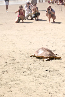
We left Charleston to get out into the creeks. Our first stop was still close to the city, but we anchored in the marshes of Inlet Creek where we broke out the kayak to explore. The kayak became our primary means of local transportation and we took it over to Isle of Palms, a beach community. There we beached the kayak and walked to the county park where sea turtles were being released by the SC Aquarium. The 73-pound loggerhead had been injured by a boat, and the Kemps Ridleys and hybrid green/loggerhead were saved from freezing in Boston, and flown to Charleston to be rehabilitated. A huge crowd showed up for the release, cheering the turtles down the beach.




After the weekend we left for the Harbor River anchorage near McClellanville, hoping to do some more marsh kayaking. We motored through what we have dubbed, "the land of the long dock" as people stretch their boat docks hundreds of feet from their houses to reach navigable water in the marshes. But, upon arrival at the anchorage, we discovered that our stuffing box was leaking way too much water, so we picked up the anchor next morning and chugged up to Georgetown to see if we needed to have it repacked. [Stuffing box - what's that? A stuffing box is where the prop shaft exits the bottom of the boat. It is supposed to keep water on the outside. Ours wasn't.] This unexpected stop at Hazzard Marina turned out really well when we learned that the packing nut only needed to be tightened. The tense day softened into a wonderful evening as we walked through this beautiful, historic town, and settled into a terrific dinner at the Rice Paddy restaurant. Oh, and let's not forget the added benefit of land showers at the marina!


Wednesday morning after picking up some fresh shrimp and other special provisions, we left the dock and turned up the Waccamaw River. Here we had enough space and depth to comfortably unfurl the jib for an assist to the motor. The view completely changed as we moved further inland. The forests changed to pines; the cypress swamps just gorgeous. The seabirds disappeared and osprey nests started to appear in the high trees and on the markers. Osprey pairs were tending to young in the nests, though we didn't see the chicks. This night we chose to anchor in Prince Creek, a completely uninhabited stretch of water off the Waccamaw. Another peaceful place where the only sounds are bird calls and the wind in the trees. We may never pick up the anchor...we think we have enough food to last a month...


Inlet Creek: +32° 47' 0.06", -79° 49' 30.06"
Harbor River: +33° 2' 4.08", -79° 32' 26.22"
Georgetown: +33° 21' 38.64", -79° 16' 47.94"
Prince Creek: +33° 34' 52.80", -79° 5' 49.56"


After the weekend we left for the Harbor River anchorage near McClellanville, hoping to do some more marsh kayaking. We motored through what we have dubbed, "the land of the long dock" as people stretch their boat docks hundreds of feet from their houses to reach navigable water in the marshes. But, upon arrival at the anchorage, we discovered that our stuffing box was leaking way too much water, so we picked up the anchor next morning and chugged up to Georgetown to see if we needed to have it repacked. [Stuffing box - what's that? A stuffing box is where the prop shaft exits the bottom of the boat. It is supposed to keep water on the outside. Ours wasn't.] This unexpected stop at Hazzard Marina turned out really well when we learned that the packing nut only needed to be tightened. The tense day softened into a wonderful evening as we walked through this beautiful, historic town, and settled into a terrific dinner at the Rice Paddy restaurant. Oh, and let's not forget the added benefit of land showers at the marina!


Wednesday morning after picking up some fresh shrimp and other special provisions, we left the dock and turned up the Waccamaw River. Here we had enough space and depth to comfortably unfurl the jib for an assist to the motor. The view completely changed as we moved further inland. The forests changed to pines; the cypress swamps just gorgeous. The seabirds disappeared and osprey nests started to appear in the high trees and on the markers. Osprey pairs were tending to young in the nests, though we didn't see the chicks. This night we chose to anchor in Prince Creek, a completely uninhabited stretch of water off the Waccamaw. Another peaceful place where the only sounds are bird calls and the wind in the trees. We may never pick up the anchor...we think we have enough food to last a month...


Inlet Creek: +32° 47' 0.06", -79° 49' 30.06"
Harbor River: +33° 2' 4.08", -79° 32' 26.22"
Georgetown: +33° 21' 38.64", -79° 16' 47.94"
Prince Creek: +33° 34' 52.80", -79° 5' 49.56"
April 16-26, 2012... Charleston, SC
We're not in Cumberland anymore, Toto. So much to see, do, eat! After our sojourn at an essentially uninhabited island, being here is a real culture shock. But we dove right in, walking the beautiful streets, taking in the architecture, historic sites, the atmosphere and lively neighborhood around the College of Charleston, shopping the big weekend farmers market, and the smells -- especially the honeysuckle in bloom everywhere. Makes us wish we had a scratch 'n sniff blog so that we could preserve and share this aroma that was in formal gardens, snaking up lamp posts, growing like weeds in alleys and on fences.


The Ravenel Bridge connects downtown Charleston to towns east of the Cooper River. It is a beautiful work of art, and we thought the best way to enjoy it would be to walk across. A little research revealed it is 2.5 miles long, and we had walking to do on both ends, so we combined learning the bus system with the walk. Two buses from where we are on the Ashley River got us to Mount Pleasant, where we could walk to the waterfront park and pier and start the walk back west over the bridge. The views of the harbor and the USS Yorktown from above were pretty dramatic, but the views up the cables of the bridge were downright breathtaking. John only took about 200 pictures...


Charleston is known as the Holy City because of all the church steeples visible throughout. And of course we found the temple too. Lots of columns... This is the south.


As a tourist destination, the city works hard to take care of its visitors. For example, there are three free trolley bus lines. And the number of brochures, guides, and maps will keep you from getting lost. Large and small cruise ships stop here disgorging lots of people. But we found that if you get away from the historic downtown, its overpriced mediocre restaurants, and tchotchke shops, you can get a better feel for the city.


People do live here -- it isn't just a Disneyland -- and it is fun to find the places where locals go. We took in a dance theatre performance at the Sottile Theatre, even though we had to bundle up in foulies to get there as a cold front roared through town and a wet dinghy ride was promised. The weather was not conducive to kayaking, as the daytime temperatures dropped to the 50s-60s, the winds were high, and the currents crazy. So, we'll pick that up again when we head back into the marshes. And speaking of the cold, we couldn't believe the nighttime temps fell into the 40s for almost a week! We decided we are moving north way too fast... Gotta slow down...


The Ravenel Bridge connects downtown Charleston to towns east of the Cooper River. It is a beautiful work of art, and we thought the best way to enjoy it would be to walk across. A little research revealed it is 2.5 miles long, and we had walking to do on both ends, so we combined learning the bus system with the walk. Two buses from where we are on the Ashley River got us to Mount Pleasant, where we could walk to the waterfront park and pier and start the walk back west over the bridge. The views of the harbor and the USS Yorktown from above were pretty dramatic, but the views up the cables of the bridge were downright breathtaking. John only took about 200 pictures...


Charleston is known as the Holy City because of all the church steeples visible throughout. And of course we found the temple too. Lots of columns... This is the south.


As a tourist destination, the city works hard to take care of its visitors. For example, there are three free trolley bus lines. And the number of brochures, guides, and maps will keep you from getting lost. Large and small cruise ships stop here disgorging lots of people. But we found that if you get away from the historic downtown, its overpriced mediocre restaurants, and tchotchke shops, you can get a better feel for the city.


People do live here -- it isn't just a Disneyland -- and it is fun to find the places where locals go. We took in a dance theatre performance at the Sottile Theatre, even though we had to bundle up in foulies to get there as a cold front roared through town and a wet dinghy ride was promised. The weather was not conducive to kayaking, as the daytime temperatures dropped to the 50s-60s, the winds were high, and the currents crazy. So, we'll pick that up again when we head back into the marshes. And speaking of the cold, we couldn't believe the nighttime temps fell into the 40s for almost a week! We decided we are moving north way too fast... Gotta slow down...
April 14-15, 2012... To Sea Again
We departed Cumberland Island on the falling tide to take advantage of the current in the Cumberland Sound and St. Marys River. What we hadn't figured on was the east wind turning that 'wind against tide' into a washing machine outside the inlet. So we and a flotilla of cruising boats all bounced our way out to sea. Once we turned to the northeast things settled down a bit and we began our journey to Charleston. Most of the journey was fair, some sailing, some motorsailing, winds really not all that great.
Overnight things got a little tense. John was on watch, Patti sleeping. Change in sail trim awakened Patti -- found John on deck trying to avoid a trio of cargo ships moving nearby. Eventually we figured out that two were bound for Savannah and one was leaving the shipping channel. We were at least 20 miles east of Savannah at the time and had no clue that we were in an area where all these ships would converge. More than a little unnerving to have to deal with this in the middle of the night. To make things worse, one of the ships nearby did not hear our call, or did not recognize that we were hailing. So, our lesson learned is that we need AIS if we plan to sail in or near shipping channels.
With morning, all seemed benign. The wind dropped to zero, and we motored into Charleston harbor. Fort Sumter, the churches of Charleston on the skyline, and the Ravenel bridge were welcome sights. Up the Ashley River we anchored opposite the municipal marina.


Charleston: +32° 46' 32.64", -79° 57' 11.22"
Overnight things got a little tense. John was on watch, Patti sleeping. Change in sail trim awakened Patti -- found John on deck trying to avoid a trio of cargo ships moving nearby. Eventually we figured out that two were bound for Savannah and one was leaving the shipping channel. We were at least 20 miles east of Savannah at the time and had no clue that we were in an area where all these ships would converge. More than a little unnerving to have to deal with this in the middle of the night. To make things worse, one of the ships nearby did not hear our call, or did not recognize that we were hailing. So, our lesson learned is that we need AIS if we plan to sail in or near shipping channels.
With morning, all seemed benign. The wind dropped to zero, and we motored into Charleston harbor. Fort Sumter, the churches of Charleston on the skyline, and the Ravenel bridge were welcome sights. Up the Ashley River we anchored opposite the municipal marina.


Charleston: +32° 46' 32.64", -79° 57' 11.22"
April 5-14, 2012... Cumberland Island, GA
Beautiful, isolated, wild, peaceful. Most of Cumberland Island is national park. The ferry comes a few times a day with day trippers and campers, but after the last ferry leaves at 4:45pm, quiet settles over the island. The only sounds those of the wild turkeys gobbling, the seagulls crying, and the big plops of rays as they break the surface and drop back into the water. There are no services, so you are on your own anchored here. Our solar panels kept the batteries topped up, and we had enough food to live on, so we stayed till we felt we had kayaked and hiked enough.


The island is magnificent. The west coast expands and recedes with the 7-foot tides, exposing miles of marshland. The forests of live oaks, thickly hung with Spanish moss, and understory palms, take your breath away. And the east coast sand dunes on the ocean side, are starkly beautiful. We hiked till our hips hurt, but it would takes weeks to discover all there is to know about this place.


We alternated hiking days with kayaking days. The currents are very strong, and if wind opposes, you can get lots of chop, so sometimes there was much moaning as sore shoulders pulled against the water. But, how wonderful to paddle the marshes, watching the tides flood the grasses and open new waterways to us. We were sometimes challenged to find our way out of the channels before the low tides left us stranded. Dolphins were everywhere and they would come close when we kayaked in open water. We thought they would stay longer if we sang to them, so they got loud, off-key versions of masterpieces such as the Flintstones theme song.

We took some time to visit the remains of the human habitations on the island. The Carnegie family left the biggest imprint. We started with the ruins of the Dungeness mansion built in the 1880s, which eventually burned to the ground. We both had the same thought; this was Mandalay - the fictional home of the DeWinters in the movie Rebecca! Not much left there to see but the gate, the walls, the cemetery, and the wild horses (one of which almost ran us down.)


We also went to Plum Orchard, a house that is intact, and was built as a wedding gift for a Carnegie son in the 1890s. Tiffany lamps were commissioned for this house, lots of modern conveniences built in. It overlooks the Brickhill River, so we paddled the 8+ miles to get there.


Finally, Cumberland Island is just across the sound from Kings Bay submarine base. We watched submarines being escorted in and out of the base 4 times while anchored there. It is quite a spectacle, and no secret. How things change.


Subscribe to:
Posts (Atom)